Hear the Key West "Voices of History™" on our Phone Tour (305) 507-0300
The Outer Mole
CIRCA 1845
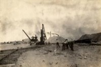
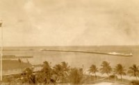
Historic Marker number 44 is located at the end of Southard Street with the Ingham and Mohawk markers.The concrete pier in front of you has gone through a number of changes over the years but its origins date back to before the Civil War. Fort Taylor was built as a defensive fortress in 1845. It originally sat one thousand feet from the shores of Key West and was connected by a wooden causeway and draw bridge. A small land embankment called a “cover face†sat behind the fort at its entrance facing Key West. A wooden dock extended from the cover face and is considered to be the original location of the Outer Mole pier.At the turn of the nineteenth century, in an effort to expand the Navy base, the water surrounding Fort Jefferson and the cover face was filled with dredge material leaving the fort land-locked.During World War I, engineers replaced the wooden pier with a massive concrete structure that fits the modern definition of a mole pier. It is a combination of a dock and breakwater built to protect ships and submarines at the numerous piers that had been built in the harbor. Sand and marl from the surrounding sea bed were used to fill the concrete blockade. Construction on this project began shortly after World War I.The Outer Mole is a deep-berth pier that is 580 feet long with a deck height of 7 feet. It has been used to dock vessels up to 855 feet in length. The Navy retained ownership of the Mole Pier when the former Key West Naval Station was sold at public auction in 1986. It is currently used as a berth for Navy, Coast Guard, NOAA, and cruise ships.